Nederlands satellietinstrument SPEXone produceert wereldkaart fijnstof

Klimaatsatelliet PACE viert op 8 februari eerste jaar in de ruimte

NASA lanceerde op 8 februari 2024 klimaatsatelliet PACE met aan boord het Nederlandse fijnstofinstrument SPEXone. Een jaar lang observeren levert nu een driedelige wereldkaart op van aerosolen. Die toont de verspreiding van fijne en grove aerosolen en van deeltjes die zonlicht reflecteren of juist absorberen. Dat laatste heeft respectievelijk een afkoelend en opwarmend effect op het klimaat. SPEXone is gebouwd door SRON en Airbus Netherlands, met ondersteuning van TNO.

Aerosolen zijn kleine deeltjes als roet, as en woestijnstof in de atmosfeer, ook wel fijnstof genoemd. Ze hebben een netto afkoelend effect op het klimaat, maar in welke mate is onduidelijk. De marge loopt van 0,2 tot zelfs 0,9 graden dempende invloed op de mondiale opwarming. Fijnstof beïnvloedt het klimaat zowel direct via reflectie en absorptie van zonlicht, als indirect door als startpunt te fungeren voor wolkvorming. Het gebrek aan laaghangende bewolking is bijvoorbeeld een van de oorzaken van het recordwarme jaar 2024.

Wereldkaart
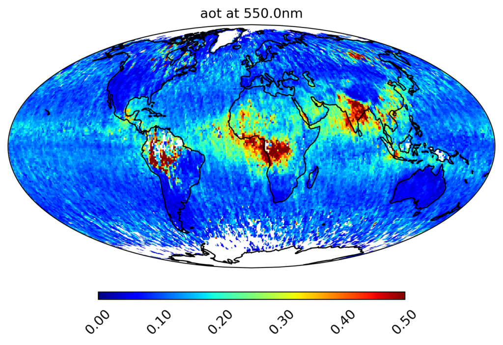
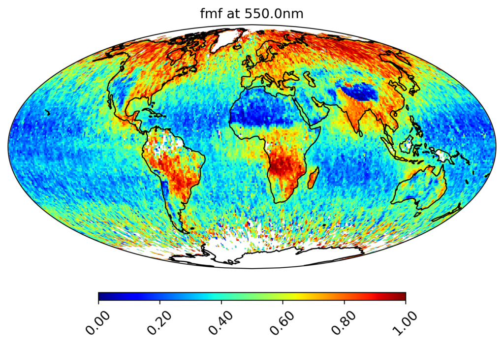
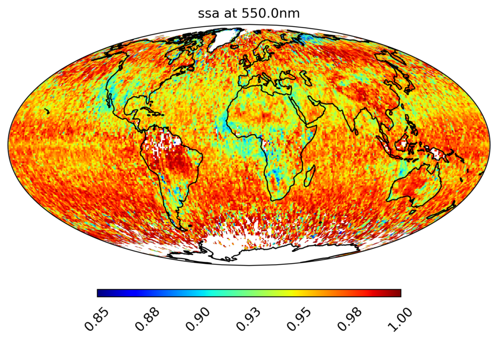
Na een jaar in de ruimte heeft het team nu drie wereldkaarten van aerosol geproduceerd. De eerste toont de verdeling van aerosolen over de aardatmosfeer. De tweede kaart toont de hoeveelheid fijne aerosolen ten opzichte van het totale aantal. Hier zien we dat fijne deeltjes vooral voorkomen boven gebieden met veel verkeer en industrie zoals India en regio’s met veel branden zoals midden-Afrika en Siberië. Woestijnstof en zeezout zijn juist grover fijnstof, wat overeenkomt met de blauwe pixels op de locatie van woestijnen en oceanen. De derde kaart geeft de hoeveelheid reflecterende aerosolen—met afkoelend effect—ten opzichte van het totale aantal aerosolen op die plek. Dat geeft een totaalbeeld van het directe effect van fijnstof op het klimaat.

Klimaatmodellen
‘De volgende stap is dat we aan de knoppen gaan draaien van klimaatmodellen totdat die ditzelfde beeld gaan produceren,’ zegt Otto Hasekamp (SRON), leider van het SPEXone-team. ‘Dan weet je dat je de juiste eigenschappen van aerosolen in de modellen hebt zitten. En dan kennen we de directe dempende invloed die ze hebben op de opwarming van de aarde, de optelsom van reflectie en absorptie.’

Wolken
Wat dan nog overblijft is de indirecte invloed die aerosolen hebben op het klimaat, via wolken. Die ontstaan als waterdamp zich kan hechten aan deeltjes in de lucht en zo druppels vormen. Met meer aerosolen moet de waterdamp zich over meer kernen verdelen en krijg je dus kleinere druppels. Maar de mate waarin dit geldt is onbekend. Hasekamp: ‘Ook op dit vlak gaan we het komende jaar aan de slag met klimaatmodellen. De wereldkaart met fijne en grove aerosolen geeft ons daarvoor de data, omdat de grootte van een aerosoldeeltje bepaalt of het geschikt is om een wolkendruppel te vormen.’

Nederlandse uitvinding
Eppo Bruins, minister van Onderwijs, Cultuur en Wetenschap (OCW): ‘Ik ben onder de indruk van het onderzoek dat SRON met deze Nederlandse uitvinding doet. De atmosfeer is een complex systeem en het klimaat is van grote invloed op ons leven. We hebben nog onvoldoende kennis over de precieze werking van de atmosfeer en werking van klimaatverandering. Met dit onderzoek kunnen de klimaatmodellen sterk verbeterd worden, de kennis kan zo meteen benut worden.’

Figuur 1: Wereldkaart van de hoeveelheid aerosol, getoond als de “aerosol optische dikte”. De kaart toont voor iedere plek op aarde de gemiddelde waarde voor de periode maart t/m december 2024.

Figuur 2: Wereldkaart van de hoeveelheid fijne aerosolen ten opzichte van de totale hoeveelheid aerosolen. Woestijnen en oceanen zijn duidelijk in blauw te zien, omdat woestijnstof en zeezout grovere aerosolen zijn. Regio’s met veel industrie en verkeer (bijv. India) en gebieden met veel branden (bijv. midden-Afrika en Sibierië) zijn rood, omdat die processen juist fijnere deeltjes produceren. De kaart toont voor iedere plek op aarde de gemiddelde waarde voor de periode maart t/m december 2024.

Figuur 3: Wereldkaart van de hoeveelheid reflecterende aerosolen ten opzichte van de totale hoeveelheid aerosolen. Reflecterende aerosolen (rood) hebben een afkoelend effect. Absorberende aerosolen (blauw) hebben een opwarmend effect. Rookdeeltjes van bosbranden absorberen zonlicht, wat duidelijk te zien is in Californië, Noord-Siberië en midden-Afrika. De kaart toont voor iedere plek op aarde de gemiddelde waarde voor de periode maart t/m december 2024.

De wereldkaarten worden binnenkort gepubliceerd in Geophysical Research Letters. SPEXone is ontwikkeld door een Nederlands consortium bestaande uit SRON en Airbus Netherlands B.V., daarbij ondersteund door TNO. SRON en Airbus zijn verantwoordelijk voor het ontwerp, de assemblage en het testen van het instrument. De wetenschappelijke leiding ligt in handen van SRON. SPEXone is een publiek-privaat initiatief dat mogelijk gemaakt is door het NSO met door OCW beschikbaar gestelde middelen en door SRON/NWO-I en ondersteund door private investeringen van Airbus Netherlands B.V.

PACE climate satellite celebrates first year in space on February 8

On February 8th 2024, NASA launched its PACE climate satellite with onboard the Dutch aerosol instrument SPEXone. A full year of observations now yields a world map of aerosols. It shows the distribution of fine and coarse aerosols and of particles that reflect or absorb sunlight. The latter respectively have cooling and warming effects on the climate. SPEXone was built by SRON and Airbus Netherlands, with support from TNO.

Aerosols are small particles in the atmosphere such as soot, ash and desert dust, also called particulate matter. They have a net cooling effect on the climate, but to what extent is unclear. The estimate ranges from 0.2 to as much as 0.9 degrees dampening influence on global warming. Aerosols affect the climate both directly via reflection and absorption of sunlight, and indirectly by acting as condensation cores for cloud formation. For example the lack of low-level cloud cover is one of the causes of the record-warm year 2024.

World map
After a year in space, SRON’s SPEXone team has now produced three global aerosol maps. The first shows the distribution of aerosols across Earth’s atmosphere. The second map shows the amount of fine aerosols relative to the total number of both fine and coarse aerosols. Here we see that fine particles mostly occur above areas with much traffic and industry such as India and regions with many fires such as central Africa and Siberia. Desert dust and sea salt, on the other hand, are coarser particulate matter, corresponding to the blue pixels on the locations of deserts and oceans. The third map shows the amount of reflecting aerosols—with a cooling effect—relative to the total number of aerosols at that location. This gives an overall picture of the direct effect of particulate matter on the climate.

Climate models
‘The next step is to play around with variables in climate models until they produce this same image,’ says Otto Hasekamp (SRON), leader of the SPEXone team. ‘Then you know you have the right properties of aerosols in the models. And then we know the direct damping influence they have on global warming, the sum of reflection and absorption.’

Clouds
Then what remains is the indirect influence of aerosols on the climate, through cloud formation. Clouds form when water vapour attaches to particles in the air, forming droplets. With more aerosols, the water vapour is distributed over more condensation cores, so you get smaller droplets. But the extent to which this applies is unknown. Hasekamp: ‘This is another aspect that we will be working on with climate models in the coming year. The global map of fine and coarse aerosols provides us with the input for this, because the size of an aerosol particle determines whether it is suitable to form a cloud droplet.’

Dutch invention
Eppo Bruins, the Dutch Minister of Education, Culture and Science, says: ‘I am impressed by the research SRON is conducting with this Dutch invention. The atmosphere is a complex system and climate has a major impact on our lives. We still have insufficient knowledge about the exact functioning of the atmosphere and climate change. With this research, climate models can be strongly improved, so the knowledge can be used immediately.’

Figure 1: World map of the amount of aerosol, shown as the Aerosol Optical Depth. The map shows the average value for each location on earth for the period March to December 2024.

Figure 2: World map of fine aerosols relative to total aerosols, including both fine and coarse. Deserts and oceans are clearly shown in blue because desert dust and sea salt are coarser aerosols. Regions with a lot of industry and traffic (e.g. India) and areas with a lot of fires (e.g. central Africa and Siberia) are red, because those processes produce finer particles. The map shows the average value for each location on earth for the period March to December 2024.

Figure 3: World map of the amount of reflective aerosols relative to the total amount of aerosols, including reflecting and absorbing. Reflecting aerosols (red) have a cooling effect. Absorbing aerosols (blue) have a warming effect. Smoke particles from forest fires absorb sunlight, which can be clearly seen in California, northern Siberia and central Africa. The map shows the average value for each location on earth for the period March to December 2024.

The world maps will soon be published in Geophysical Research Letters. SPEXone is developed by a Dutch consortium consisting of SRON and Airbus Netherlands, supported by TNO. SRON and are responsible for the design, assembly and testing of the instrument. The scientific leadership is in the hands of SRON. SPEXone is a public-private initiative made possible by the NSO with resources made available by OCW and by SRON/NWO-I and supported by private investments from Airbus Netherlands.